
If Decolonization Is a Principle, Foalhavahi Must Return to the Maldives

Updated: Sep 25
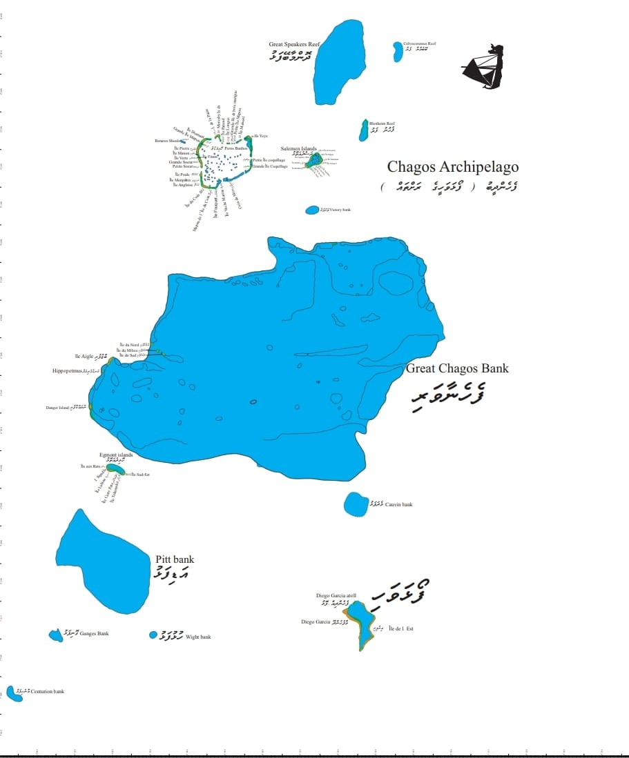
Decolonization is supposed to undo the map drawn by the last empire, not launder it. The United Kingdom did not invent the southern islands. France did not invent them. Mauritius did not live on them before Dutch and French settlement of Isle de France. What Europe called the Chagos Archipelago already had a Dhivehi geography: Foalhavahi, with named atolls, falhu (reefs and lagoons), fushi and dhoo (islands), and sailing notes for wind and current. If the principle is that a colonial cut must be healed by returning land to the people whose sea it was, the address is Male' not Port Louis.
That is the argument. It is not the argument the ICJ and ITLOS chose. They treated the French–British administrative file as the unit to be freed.
The map that still speaks Dhivehi
The chart attached to this debate, the presentation of the old Dhivehi map of Foalhavahi, is not a Portuguese portolan and should not be sold as one. It is a reconstruction of names Maldivian seafarers and fishermen used for the islands now printed as Chagos.

The late Mohamed Ibrahim Haleem of Dunfini (Badialibeyge Haleem) compiled those names in Foalhavahi Furayfu map puts them back on a latitude–longitude frame from about 2°40′ S to 7°50′ S and 71°00′ E to 73°40′ E: the same band as Peros Banhos, the Great Chagos Bank, Salomon, Egmont and Diego Garcia.

Look at what the sheet actually names. The large central body is Fehenaavari; the heading on the right is Fehendheebu. Around and inside that bank sit Vashafalhu, Medhafalhu, Adifalhu, Hulhufalhu, Gonifalhu, Maanehifalhu. On the western rim of the great bank: Uthurufushi, Medhufushi, Dhekunufushi, Baazufushi, Kandugerirah, Nurahkaafushi. South-east of the bank a hooked island is labelled Foalhavahi, with Irufishi and Fehendhilpolhu. North of the bank lie Dhonmaabeyfalhu, Beybehyaafalhu, Fehunufaru. Insets carry Holhimadulu and Rasdhe Atholhu, Holhidhe Atholhu. Island names in the same hand include Dheydhoo, Kudhibolifushi, Bodubolifushi, Holhivaruthila, Maahiri, Maamendhoo, Kukulhudhoo, Kakidifishi, Rahadhoo, Kandhoo, Kafidhoo, Mahyaafushi, Labaridhoo, Kanifushi, Gaufishi, Rithaafishi, Gaskalhufushi, Finey, Hulhiyandhoo, Maalhendhoo, Naladhoo, Kudarah, Dhigurah, Maandoodhoo, Hulhumendhoo, Rahaa, Mendhoo, Lhuhifushi, Mahaanafushi, Boidhoo, Lonufushi, Handifushi, Maadhali, Fehendhoo, Lhohifushi, Sathuranfushi, Landaidhoo.
Those are not French estate titles. They are the ordinary grammar of Maldivian geography: Atholhu, Falhu, Fushi, Dhoo, north island and south island (Uthuru- / Dhekunu-), big and small (Bodu- / Kuda-). Later Maldivian readings pair Holhimadulu with Peros Banhos, the northernmost atoll, some 285 nautical miles south of Gan in Addu; Kandhoo with Île du Coin; Foalhavahi in a narrower sense with Diego Garcia; Adi Dheydhoo with Île Yeye. The pairings can be argued island by island. The pattern cannot: this is a ridge named from the north, in the language of the people who sailed it.
The boxed note on the same sheet is not a land title. It is a pilot book. It tells when wind inside the Fehendheebu islands (Foalhavahi) runs with the incoming air, when from mid-December to mid-April it sets eastward, when in June, July, August and September it sets toward Male, and how current in the Fehenaavari ground shifts-strong flow to the south-east, weaker flow to the north-west-and how confused wind and sea raise short, dangerous swell on the shallows. That is the knowledge of men who expected to go there and come back. A state that only administered coconut oil from Port Louis did not need that sentence. A Maldivian odi did.
Names versus brands
“Chagos” is a European chart word. “Chagossian” is a late political brand built from that word. Ilois is French Creole for “islander,” a plantation-era label. Foalhavahi is older in living language. Hassan IX, writing from Cochin around 1560–61, called himself owner of the Maldives, the three southern patanas of Suadhoo, and the seven islands of Pullobay. Pullobay is read as Foalhavahi. Pyrard’s Pollouoys and later Polvera forms sit in the same family. Europe did not discover a nameless reef. It overwrote a name.
What the 1555 wreck does-and does not-prove
The Portuguese nau Conceição, captain Francisco Nobre, struck the reefs of Pêro dos Banhos on 22 August 1555. Manoel Rangel wrote the survivor narrative and reached Cochin in January 1557. That story is real. It is also routinely asked to carry more than it will bear.
Rangel’s wreck island is not a village. The people left on the sand lived on birds, eggs, crabs and turtles. They dug wells. When the birds were gone they died. Summaries of the same text describe grass, weeds, thousands of birds, a flat cay-and this before the later coconut-plantation landscape. They built boats because the place could not keep them. That is not a settled Foalhavahi town feeding strangers
The “dark-skinned people” enter after the Portuguese leave the reef. Survivors who reached inhabited islands to the north were taken to a ruler and sent on toward Cannanore and Cochin. Those hosts were Maldivians. A strained reading of negros and a “Moor” king is sometimes used to plant a town on Peros Banhos in 1555. The stronger reading is: wreck on an empty or near-empty cay → open boat → Maldives → king → India. Maldivians are in the story as namers, seafarers and rescuers. They are not the population Rangel found already housed on the wreck reef.

Permanent plantation settlement on those cays begins in the late eighteenth century under French concessions from Île de France. Enslaved labour from Madagascar and Mozambique, later Indian indenture, became the Ilois. That community is real. Expelling it was a crime. It does not convert a French copra estate into original title, and it does not erase the Dhivehi map that already had Holhimadulu and Foalhavahi on the page.
Whose colony was the file?
From 1744 France claimed Peros Banhos. From the 1780s planters in Port Louis took concessions. In 1814 Britain took Mauritius and its dependencies. Until 1965 London ran the islands from that file. In 1965 it cut the file so Diego Garcia could become a base. The ICJ in 2019 said Mauritian decolonization was not completed. ITLOS then treated Mauritius as the coastal state. The General Assembly voted 116–6. None of that joined Male' as a title claimant. None of it tried whether France had the right to treat Fehenaavari as empty
Uti possidetis freezes the colonial office map. On that doctrine Mauritius wins, because Chagos sat in the Mauritian drawer. Seychelles was detached and became a state; Chagos was not. The Maldives was a protected sultanate with its own path. Courts that accepted the Mauritius thesis were freeing that unit.
They were not asking who named Kandhoo before Île du Coin existed on a French lease.
A principle that only returns land to the last clerk is not decolonization. It is succession.
The nearest inhabited country, the language of the toponyms, the 1561 sentence, the wreck-rescue, the rukugai thahjehun survey voyages remembered in families such as Kerafa Alifulhu’s, and the Haleem sheet all point north. Port Louis is more than a thousand miles farther than Addu. Geography is not title. It is a reason the colonial file looks accidental.
The people who cannot be written out
Honesty still requires this: the people put on ships between 1967 and 1973 were Ilois born on the estates, not an Addu village restored intact. They have a right of return that does not depend on whether the next flag is the Union Jack, the Mauritian quartered arms, or the Maldivian crescent
A claim by Maldivians identifying them as a "Portuguese brand" refers to a region populated by Maldivians. There may be a potential link between this group and Maldivians that could be uncovered through genetic ancestry research. Currently, the Maldives has only 141 DNA ancestry samples, collected from only six islands, representing the sole ancestry survey of living Maldivians.
Additionally, the persistent colonial practice of disputing over islands while the islanders remain marginalized continues. Foalhavahi can be Maldivian in name and cultural memory while also being home to a Creole community that emerged on those shores. Both realities coexist. However, only one has been acknowledged in the legal arena.
The principle, applied
If decolonization means “give the colony back to the colony that administered it,” Mauritius is the answer the courts already wrote. If it means “do not let the last European paperwork decide who the southern ridge belonged to,” the paperwork is the problem. France did not receive Foalhavahi from Male' by deed. Britain did not inherit a sultan’s grant. They occupied a named sea and later staffed it with slaves. Returning that occupation to the plantation capital is a tidy ending for 1965. It is a poor ending for Holhimadulu, Fehenaavari, Kandhoo and Foalhavahi.
The attached map will not, by itself, move a boundary. Advisory opinions do not, by themselves, move one either. What the map does is make the silence visible: dozens of Dhivehi names, a monsoon note, a ridge drawn as if it belonged in the same atlas as Addu,and a legal process that never put that atlas on the table. If decolonization is a principle and not a slogan, the territory called Chagos has to be argued as Foalhavahi, and Foalhavahi has to be argued with the Maldives in the room.
Note :
The Ilois, also referred to as Chagossians, are an ethnic group originally from the Chagos Archipelago in the Indian Ocean. Between 1967 and 1973, the British government forcibly displaced the Ilois from their homeland to establish military facilities, mainly on Diego Garcia. Most Ilois were relocated to Mauritius, with smaller groups moved to Seychelles and the United Kingdom. This forced displacement has since been the focus of legal challenges and international scrutiny. The Chagos Archipelago, now part of the British Indian Ocean
The territory was already inhabited when Portuguese explorers discovered it in the 16th century and it later became a point of contention among European powers. The "dark-skinned people" arrived after the Portuguese departed from the reef. Survivors who reached the inhabited islands to the north were taken to a Maldivian ruler and subsequently sent towards Cannanore and Cochin. The Portuguese nau Conceição, commanded by Captain Francisco Nobre, struck the reefs of Pêro dos Banhos on 22 August 1555. Manoel Rangel documented the survivors' story and arrived in Cochin in January 1557. These hosts were Maldivians.


Comments